ROSIE'S REGIONS 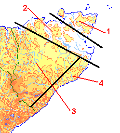 |
J H ROSIE
The last assesment of the status of
the macro moths in Caithness was given by J H Rosie in an article
published in Entomologist's Gazette Volume 27 in 1976. His assessment
is an important baseline from which to judge changes in moth
poplulations and is referred to in the species accounts on this web
site. Modern computer aided recording is based on the 10km squares
of the National Grid whereas Rosie based his assessment on five regions.
Region 1: The northeastern corner of the County. A core of central moorland surrounded by a narrow coastal strip of agricultural land, largely grassland but with some arable. The main change since Rosie’s time has been the growth of widespread commercial coniferous plantations and small pockets of deciduous woodland planted by landowners under environmental improvement schemes. Region 2: A belt of arable land running southwest of Region 1 limited in the south by a line running from the close to the Caithness/Sutherland border in west to Ulbster in east. Established hedges of hawthorn and beech often demarcate fields and there are scattered plantations of mixed deciduous tees. Probably very little change from Rosie’s time. Region 3: Described rather dismissively by Rosie as “heather moor with a little rough pasture” the central moorland plateau is the most fragile and complex habitat in the County. With Sutherland it contains the internationally important Flow Country. Apart from a greater recognition of the ecological importance of the area, the main change since Rosie’s time has been the establishment of extensive commercial coniferous plantations largely financed through tax incentives in the 1980’s. Region 4: An area along the southeast backed by well drained moorland on the landward side. This area is divided by burns flowing through straths with well established mixed deciduous woodland. There is some farmland, mainly permanent grassland. Little changed since Rosie's time though woodlands have probably deteriorated and Rumster Forest has been clear felled. Region 5: The coast, which is largely unchanged since Rosie's time. 5(a) the cliffs and cliff tops which form the major part of the Caithness coastline and is divided by occasional geos, some of which shelter specialist plants and shrubs. 5(b) sandy beaches backed by sand dunes and links, found mainly at Reay, Dunnet and Sinclair Bays ROTHAMSTED INSECT SURVEY
As part of the Rothamsted Insect
Survey, Rothamsted Research operated moth traps at seven sites in
Caithness during the 1980's and the 1990's. Trapping appears to
have ceased in 2002 by which time the scheme had produced over 14,500
records.
INDEPENDANT
RECORDERS
A small number of individual recorders operated in County during the latter part of the 20th Century and in the early part of the 21st. Some of these recorders' records have been made available through the Bilological Recording Centre but many must still be kept in private papers.
|